Please wait, I'm coming over...

Last Changed 9/2/2016 |
||
|
We had always referred to the GPS radio that connects to the computer as a "GPS puck" but it appears that "GPS
mouse"
is becoming the common terminology. |
||
We place the GPS puck on the dash of Red Rover. Red Rover's windshield is more vertical that a typical automobile and there is a visor over the windshield. The result is that the GPS puck has a smaller window of the sky than in a typical automobile. GPS requires the radio to be able to see at least three, and preferably four or more satellites. When the GPS puck starts up, there is a period where it has to find, lock on, and verify those satellites before the radio can determine your location. The startup time is called Time-to-First-Fix (TTFF) |
||
Original GPS Pucks |
||
 |
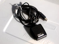
We started with the GPS puck that came with the CoPilot software package. The CoPilot GPS
puck is waterproof and has a magnetic
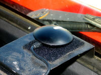
base. We mounted a piece of steel between the dash and windshield that it stuck to. The CoPilot GPS puck worked fine except for start up. Sometimes the TTFF for the CoPilot GPS puck would take up to 15 minutes. We assumed it was because of the windshield and visor of Red Rover. We researched mounting the GPS puck outside. This would have required cable extensions and creating a base somewhere on the visor or one of the door mirrors. At a seminar, we were told that the new GPS puck from Delorme (Street Atlas USA), the LT20, was the greatest thing on Earth. We buy new versions of Street Atlas USA to stay current so this time we bought the version that included the LT20. The LT20 does not have a magnetic base so we had to add a Velcro attachment to our windshield mount. |
|
 |
||
click on images to enlarge |
||
Delorme has a piece of software that allows the LT20 to be shared with multiple software packages. We could have CoPilot, Streets & Trips, and Street Atlas USA running at the same time. That piece of software also had a display that looked like a conventional GPS unit with direction, speed, and a altitude displays. Dale liked checking the altitude in the Rockies. The software driver for the LT20 also has a feature that would let the LT20 coast along for a while pretending it had a 4 satellite fix with only 3 satellites as sometimes happens with crests. This is possible because 4 satellites determine where you are in space; 3 satellites can determine your position by assuming the center of the Earth as the fourth satellite. For a short period of time, the software driver just kept using the same altitude if the satellite count dropped to 3. However the TTFF time for the LT20 is horrible. We had instances where we would be driving for 45 minutes before the LT20 would find 4 satellites. Again we assumed that the problem was our mounting location. We again researched putting the GPS puck outside. This would have been more of a problem because the LT20 is not waterproof. More research at the Delorme Forum looking for outside mounting tips resulted in the understanding that this TTFF problem was not unique to us. From the numerous complaints about the LT20 TTFF time, we came to the realization that the LT20 was a piece of junk. |
||
 |
We were looking for an outside mount GPS puck when we ran across the SiRFstar III technology. This is the most advanced GPS chip in
use today. It has the fastest TTFF. Part of the reason is that where most of the chips have a couple of hundred reference points
that the radio uses to find satellites, the SiRFstar III has 200,000 points of reference. We bought a US Globalsat BR-353 GPS puck that is waterproof, has a magnetic base and uses the SiRFstar III chip. |
|
click on images to enlarge |
||
Trying the BR-353 for the first time, we knew we had something different. We loaded the drivers on one of our laptops and plugged in the BR-353 into the laptop inside our trailer just to check out the software. The BR-353 locked on. Neither the CoPilot nor the Delorme LT20 GPS puck ever worked inside the trailer. The TTFF of the BR-353 is almost instantaneous. It is locked in to the satellites before the Navigation Computer is fully booted up. Without question, the BR-353 is the best investment we have made regarding GPS navigation. We also found a piece of software called GpsGate from Franson Technology than allows the BR-353 to be shared between multiple software applications. |
||
New Model Puck |
||
 |
Our US Globalsat BU-353 lasted for 9 years and was functional until
we updated the truck computer for navigation to Windows 10 from
Windows 7. Unfortunately the original manufacturer of the chip
used in the BU-353 decided not to supply a driver for Windows 8, 8..
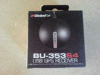
and 10. We had to acquire a newer model, the BU-353S4. The BU-353S4 is supposed to have a lot of new features but the only one we cared about was that it is supported by Windows 10. |
|
Disclaimer: The information in this site is a collection of data we derived from the vendors and from our personal experiences. This information is meant as a learning guide for you to make your own decisions Best practices and code should always be followed. The recommendations we make are from our personal experiences and we do not receive any compensation for those recommendations. |